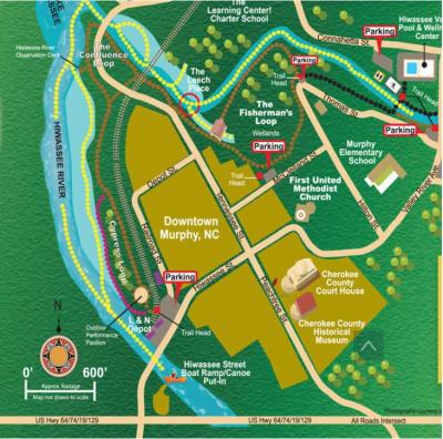
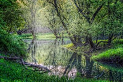
Welcome to the River Walk...
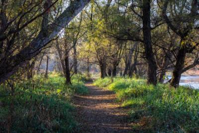
This beautiful greenway follows the Valley River and the Hiwassee River surrounding the historic town center of Murphy, North Carolina. The 4-mile walking trail includes a center loop at the confluence of these two rivers on the backwaters of Lake Hiwassee. Whether you take the trail on foot or put in for an easy paddle along the canoe trails, you'll enjoy the ecology and cultural heritage along the way.
Since it began as a concept in 2002, the River Walk has seen the successful completion of all phases of the basic trail construction between Konehete Park and the Old L&N Depot. The volunteer River Walk project team continues its work with a host of ongoing maintenance, landscaping, interpretive signage, directional signage, and additional construction projects along the trails. Ecology classes for school students are held on the trail, as are student group work days for hands-on experiences.
The Murphy RiverWalk is managed and maintained by Town of Murphy with only the Konehete Park portion maintained by Cherokee County employees. It was created as a public and private partnership with various groups, including the Town of Murphy, Cherokee County, Tennessee Valley Authority, N.C. Department of Transportation and Hiwassee River Watershed Coalition. The trail is owned by the town but sits on TVA land.
History of the River Walk
Initiated as a multi-phase master plan concept in July of 2002, the Murphy River Walk project was formally endorsed by the Mayor & Town Council of Murphy, and by the Cherokee County Board of Commissioners, in January 2003. Phase 1 opened in the fall of 2003 at Konehete Park, and a master plan for its future phases was completed by the fall of 2004. Step by step, the River Walk was completed all the way in to the Old L&N Depot on Railroad Street at the Hiwassee Street river bridge in 2010.
Enhancement and improvement activities continue on with the trail surfaces, native landscaping and interpretive markers along the way. The approximate 3-mile trail carries the potential of far reaching benefits to the community- health and recreational enhancements to Konehete Park and the Wellness center facility, economic renewal stimulus for the historic town center, eco and heritage tourism, environmental conservation, cultural and historic preservation, native plant and wildlife education, and more.
The project master plan has been completed from Konehete Park all the way to the Old L&N Depot in town. The approximate 3 mile walking trail (6 miles round trip, or however you wish to take it) follows the Hiwassee River and the Valley River, which meet to form the back waters of Lake Hiwassee and surround the historic town center of Murphy, the Cherokee County seat.
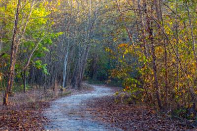
As the seasons change, and as the river and lake waters rise and recede, the River Walk & Canoe Trails tend to change character as well. You’ll find it a beautiful connection with native plant life, bird and fish species, and the waters of two rivers meeting to form a lake. The natural wonders are breathtaking any time of year.
EVERY DAY IS A GOOD DAY ON THE RIVER WALK.
Step onto the beautifully scenic Murphy River Walk at any one of these trailheads:
- The Pool/Wellness Center and ball fields at Konehete Park, the County Health Dept.
- On Hilton Street, the middle of McClelland Street.
- The Old L&N Depot at the river bridge in town.
Canoe and kayak put-ins can be found on Payne Street and Hiwassee Street just beyond the River Walk trail.
The approximate 3 miles of trail surfaces start at the far end of Konehete Park along the Valley River, and end at the Old L&N Depot by the Hiwassee River bridge.
Murphy River Walk Audio Tour
As you walk along the paths of the Murphy River Walk you will discover 19 different sign posts with QR codes taking you to short audio files describing local history, plant life, or animal life. This is a great way to learn more about the area you are visiting. Below are the scripts and companion photos to each of these QR codes. Thank you to David Vanderlaan of Heritage Partners for researching and writing all of the scripts for the audio tour.
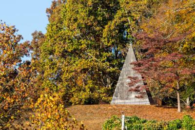
ARS Hunter Pyramid
From this vantage point, you can see one of the most unique structures in the area.
On the hill, across the river, is the ARS Hunter Pyramid. This 30 foot tall monument stands on private property so it is not accessible to the public but you can see it easily from this vantage point.
This pyramid was commissioned by Lillie Hitchcock Coit and was built around 1930 to honor her grandfather, Archibald Russell Spence Hunter.
Hunter was the first known white settler in this area, arriving in the 1820’s. He was an enterprising young man, opening a trading post, later operating a ferry crossing the Hiwassee and building a toll bridge just downstream from here.
The area population grew and a new town was formed in 1835. Initially the town was named Huntington after Hunter who served as the town’s first postmaster. In 1851 the town was incorporated and renamed Murphy after a prominent North Carolina politician, Archibald D Murphey.
The pyramid stands as a memorial to our earliest settler. The names of his wife and his niece are also inscribed on the pyramid.
Some say that the pyramid marks the graves of the Hunter Family and that their bodies are buried underneath, but that has never been confirmed.
Listen to the audio file describing this location here.
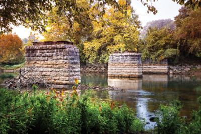
Cherokee Encampment
Look out over the river at this point.
What do you see?
To the left are the old railroad bridge pilings. To the right the Hiwassee River continues its westward journey.
Not much else.
Now close your eyes. Imagine 1,500 Cherokee People encamped on the hills across the river from where you stand.
Women and children. Old men. Uprooted from their ancestral homes by the newly arrived White Man. Waiting to be deported to a land unknown by the People. To walk and likely die on the Trail of Tears.
This place is Sacred. This is a place of ending and a place of beginning. Thousands of years of Cherokee culture is forever changed at this spot. Pause and shed a tear for what was lost. Shed a tear for what ended and began here.
Across this river and just beyond your view is the site of Ft Butler. Here the Cherokee People were gathered in advance of the deportation of the Nation to Oklahoma via what would be known as The Trail of Tears.
The young men and leaders of the Nation were imprisoned at the Fort. Women, children and the elderly camped on the river bank across from where you stand now.
The relocations of the Cherokee Nation was supposed to be voluntary. But most of the leadership of the Cherokee Nation and a majority of the People opposed it. When a small group of did agree to relocation, the US government took that agreement as authorization to force the removal of the entire Cherokee Nation.
It took nearly a year to forcibly gather the People here for deportation. From May 1838 through December of that year, nearly 3,000 Cherokee were routed through Ft Butler in route to internment camps surrounding Fort Cass which was located near present day Charleston, TN. Most of the Cherokee only spent a few days at Ft Butler before being moved on to Ft Cass.
In December of 1938, the Cherokees continued their forced journey from Ft Cass to Oklahoma during the harsh winter. Thousands died. Hunger, freezing temperatures and attacks from local settlers all took their toll. This harsh journey has come to be known as the Trail of Tears.
Learn more about the sad history of the Cherokee Removal and the Trail of Tears at the Cherokee County Historical Museum, located in downtown Murphy.
Listen to the audio file describing this location here.
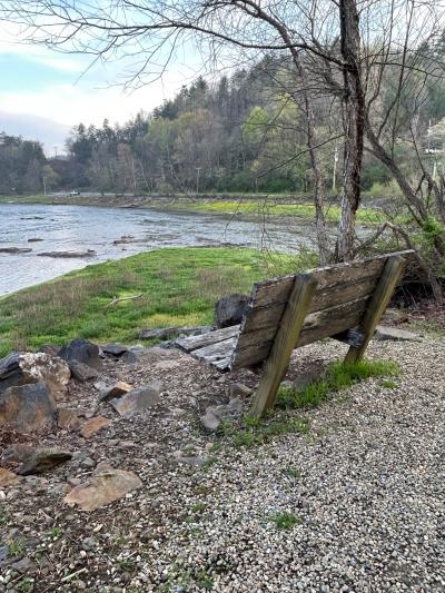
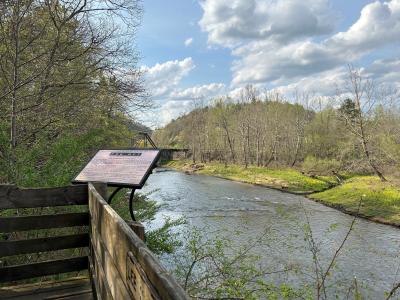
Confluence of Two Rivers
Stand here and look over 10’s of thousands of years of history. These two rivers join here. The Hiwassee is to your left, the Valley River is to your right. The rivers, once joined retain the name of the Hiwassee River as it flows westward towards Tennessee.
In the summer months, the Tennessee Valley Authority raises the level of the water in the Hiwassee with their control system of dams. This area effectively becomes a lake suitable for all types of water sport and recreation. Fishing, canoeing and kayaking are popular ways to enjoy the summer on the lake.
Before the arrival of the white man, this region was home to the Cherokee and their ancestors for thousands of years.
This place had many names over the centuries. One of the Cherokee names for this area was Klausuna, a name that meant “Large Turtle”.
The name comes from a Cherokee legend that tells of a huge turtle that would sun itself at the junction of these two rivers. The Turtle would lie out all day with no worries. He was so huge that he had no fear of the many attempts to capture or hurt him. Legend says he even survived a lightning strike.
But he soon became bored, tiring of the futile attempts of man’s attacks. He became disgusted with the world and burrow down to the center of the earth, never to be seen again.
As with most legends, there are often physical objects that tell of the story. The same is true of this legend. A huge soapstone rock carved into the shape of a turtle by ancient man was found near here.
Now residing in front of the Cherokee County Historical Museum In downtown Murphy, is this stone turtle the source of the legend or just an acknowledgment of the old story?
Listen to the audio file about this location here.
Cypress Loop
The Cypress Loop is the most primitive or most undeveloped part of the River Walk Trail.
This trail winds through an environmentally delicate area along the Hiwassee River.
Because the trail is in a protected area, it will remain as a rustic trail, as close to the natural environment as possible. Enjoy this natural area, but please do not wander off trail.
The native plants and trees provide a natural habitat for a host of birds and animals. Listen carefully as you walk along the trail for the cheerful song of the birds. Watch for the occasional deer in the meadows. Along the banks of the river, you may even catch a glimpse of a river otter of a beaver. Watch overhead as well, osprey and bald eagles often visit the area.
In the summer months, the Tennessee Valley Authority raises the level of Lake Hiwassee to the point where this area is under as much as two feet of water. This is a perfect time to launch your canoe or kayak to explore the shores of the lake.
Listen to the audio file describing this location here.

Dogwoods
The beautiful dogwood trees are native to our area. Their beautiful white and pink blooms are one of the first flowers to announce the arrival of Spring.
There are many legends that surround this tree.
The Cherokee legend tells of the Dogwood People. The Cherokee believe that a tiny people live in the dogwood trees and that this divine little race was sent to teach people to live in harmony with the forests. The legend says that these little people are very kind, they protect babies and take care of the old and infirmed.
Another legend is more religious in nature.
This legend says that Jesus had a special love for the Dogwood trees which grew to the size of great oaks at that time. So firm and strong was the tree that it was chosen as the wood for the construction of the Cross.
To be used for such a cruel purpose, greatly distressed the tree. Jesus, with his gentle pity for all living things, told the tree, “Because of your regret and pity for my suffering, never again will a Dogwood tree be used for this purpose. Never again will a Dogwood tree grow large enough to be used as a cross. It henceforth will be slender, bent and twisted.”
Thus, the beautiful Dogwood is now only a small tree, never again growing large.
You can see the flowers of these beautiful trees along the River Walk and all throughout the town in the Spring.
Listen to the audio file describing this location here.
Fisherman's Loop
This area on our River Walk is called the Fisherman’s Loop, so named because it is a popular fishing spot for our local residents.
Even before our locals discovered this fishing hole, this area was inhabited by the Cherokee and their ancestors.
But how long did the Cherokee live here? When did they first arrive? Where did they come from?
Cherokee history draws heavily on oral traditions, so exact histories are hard to define.
One theory is that the Cherokee are relative new comers to the area, arriving as late as the 13th Century.
Other theories hold that they have been here for thousands of years.
Either way, the fact that humans, either Cherokee or their ancestors, have lived here for thousands of years is well established. Archeologists believe that there has been a human presence in this area since at least 11,000 years.
This Fisherman’s Loop area is now considered a protected wetland so please do not stray off the trail. Much of the vegetation in this area is native but some of the plants you see are not native to this environment. Managers of the River Walk are slowly removing the non-native, invasive species so that the native plants can again thrive all along the trail.
Listen to the audio file describing this location here.

Great State Road
Welcome to the newest section of Murphy’s River Walk Trail.
This portion of the trail roughly follows a portion of the Great State Road that was constructed in 1837 to connect Blairsville, Georgia with Franklyn, North Carolina. This wagon road passes through here and connected a series of forts built in anticipation of the Cherokee removal.
One of the forts, Ft Butler, was here in Murphy.
The exact location of this road is well documented. The original roadbeds are still discernable in some areas, though many sections have been obliterated by subsequent road or railroad construction.
In this area, the Great State Road followed the banks of the Valley River between present day Murphy and Andrews, North Carolina. Crossing the Valley River near this spot, it went through the area that would later be our downtown before another river crossing near the site of Ft. Butler.
Though historical accounts do not specifically mention this road as part of the Cherokee removal, is most certainly was used to transport the Cherokees to Ft. Butler from points east.
Listen to the audio file describing this location here.
Invasive Plants
Most of the River Walk Trail is located on land that is owned by the Tennessee Valley Authority. Much of the land was either previously cleared for farming or cleared by TVA for the water impoundment to create Hiwassee Lake in the 1940’s. The land was then left idle and over the years a variety of plants reestablished in the landscape where the River Walk is located. Many of the plants that grew back were native plants, important to the delicate river bottom ecosystem of the valley, but, at the same time many non-native plants were brought into this area by man from all over the world. Some were brought in as ornamentals, some for erosion control and many just came to this country by traveling with human commerce.
After these non-native plants were established in our environment, they had no competition or biological control to stop their growth. They produced many seeds and then many more plants. With little or no natural diseases and few animals or insects eating them, the non-native plants grew and spread rapidly over the years. These factors resulted in many non-native plants choking out native plants in the rich cleared lands along the rivers where the River Walk is located, severely impacting the delicate river bottom ecosystem.
Since the beginning of building the trail we have been slowly removing these non-native plants and we are seeing a great variety of native plants grow in their place. Many of the native plants will reestablish on their own but some must been re-introduced. As the variety and number of native plants increase, we will see more species of insects that rely on these native plants for food returning to the area. More insect species will result in more birds and other animals that rely on them for food. The return of these native insects and animals will result in a healthier native environment.
So what are the non-native invasive plants that we find along the trail? We have a large list that includes privet, multiflora rose, kudzu, autumn olive, garlic mustard, oriental bittersweet, English ivy, honeysuckle and many more. The volume of these invasive plants is more concerning than the number of species. When the trail was started the privet was so thick you could not see 10 feet in front of you. Look away from the trail now and you can still see some of these dense masses of invasive plants.
Still, we have made a lot of process and the native plants in the areas around the trails are coming back and the environment along the trail is much healthier, more diverse and more attractive. We are seeing larger populations of birds and even more importantly, more species of birds returning to the area. This increase in wildlife numbers and diversity will continue as the ecosystem becomes healthier.
As you continue your walk, watch for birds in the bushes and trees along the trail. How many different species of birds can you identify?
Listen to the audio file describing this location here.
Konehete Veterans Park
Konehete Park is the center of Cherokee County’s Recreational Programs. The baseball and soccer fields get regular use by the many youth leagues in the area. At the west end of the park is the Hiwasee Pool and Fitness Center. This modern facility provides a workout gym, aerobic studios and a year round swimming facility.
The River Walk trail in Konehete Park was the first section of the trail to be developed. This pleasant section of the trail is a popular section for runners and walkers.
A pedestrian bridge across from the Fitness Center crosses the Valley River and connects the Park to the rest of the River Walk Trail. Future plans include adding an additional pedestrian bridge at the east end, connecting to a new trail section, currently under construction across the river.
The word “Konehete” is a Cherokee word meaning “Long Valley Place” referring to the long Valley River that flows from Andrews through Murphy. In fact, the town of Andrews stands at the site of the original Cherokee town of Coneheetoyn, which means Long Valley Town.
You may notice that the word Konehete is spelled differently in several places around town. Konehete Park is located on Connahetta Street, but the park’s name is spelled with a “K” and the street’s name is spelled with a “C”. Which is right?
The answer is that both are correct. The English spelling of the word was derived from the phonetic Cherokee word and was recorded on the maps and other official documents with different spellings, depending on who was writing it down at the time.
Listen to the audio file describing this location here.
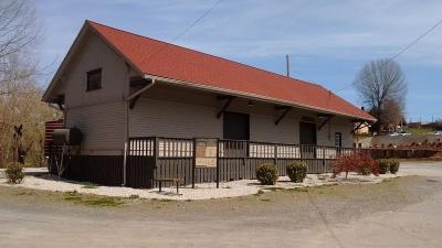
L&N Depot
Standing here at the L&N Depot, you see what little is left of a small railroad with a long history.
This small freight depot with an old boxcar and caboose on this section of track are all that is left of a railroad who’s history began in the mid 1800’s.
The idea building a railroad from Atlanta north through to North Carolina was conceived around 1850. Delayed by the Civil War, the construction began in 1874 finally making it from Atlanta to Murphy in 1891.
About that same time, the rail from the East arrived connecting Murphy to Asheville and beyond.
Connecting the two rails in Murphy would take a bit longer. Because of a legal dispute over the right-of-way ownership crosing the Hiwassee River, the connecting bridge wasn’t built until 10 years later in 1901.
For nearly half a century, the trains rolled through town.
But, improvements in the local highway system and the convenience of modern cars and trucks would soon take the profit out of the rail system. Passenger rail service through the area ended in 1948. Freight service continued for a while longer, but in the late 1980’s, when the local textile industries moved out of the area to overseas manufacturing plants, freight service also ended.
With no active rail service to the area, the track from Murphy south to Mineral Bluff was removed. The bridge over the Hiwassee dismantled.
In 1985, the North Carolina Department of Transportation purchased the remaining track from Murphy to Dillsboro, NC. Much of that rail is currently leased to the Great Smoky Mountain Rail Road for tourist train excursions, but even those trains no longer travel this far west. The last train from Murphy departed this station on July 4, 1992.
There is hope that someday, the trains will return. Perhaps one of the great steam engines will return and recreate the glories of the railroad era for us to enjoy again!
For more information on the railroad history in Murphy, stop into the Cherokee County Historical Museum, located in Downtown Murphy.
Listen to the audio file describing this location here.
The Leech Place
Stop for a moment here at this overlook above the Valley River and learn about the old Cherokee legend of the Great Leech.
When the water level is low, you can easily see a ledge of rock running across the stream just below this overlook. Just below this ledge is a deep hole in the floor of the river.
The Cherokee people would often use this rock ledge as a bridge to cross the river. From where you are standing now, the people would could look down on the ledge and the water below.
One day some men, going along the trail, saw a great red object, full large as a house, lying on the rock ledge in the middle of the stream below.
As they stood wondering what it could be, they saw it unroll and stretch itself out along the rock until it looked like a great leech with red and white stripes along its body. It rolled up into a ball and then stretched out again to its full length. It finally crawled down the rock and was out of sight in the deep hole.
Then the water began to boil and foam and a great column of white spray was thrown high into the air like a water spout and came down upon the very spot where the men had been standing. They all would have been swept into the water, but they saw it in time and ran from the place.
These men were safe, but others that came along this trail were not so lucky. More than one person would be washed into the deep water this way and their friends would later find the bodies lying on the bank of the river with their ears and noses eaten off. Soon all the people were afraid to cross the river on the rock ledge anymore and they would even avoid the trail along the river at this spot.
But then there came a young man who was not afraid. He laughed at the story and said “I am not afraid of anything in the river and I will show you”. So, one day, he painted his face, put on his finest buckskin and started off towards the river. All the while the people followed at a distance to see what would happen.
Down the trail and out onto the rock ledge he went, singing in high spirits. But, before he was even half way across the river, the water began to boil into a white foam and a great wave rose up and swept him into the deep hole, never to be seen again!
So, watch carefully as some would say that the Great Leech still lurks in the water below!
Listen to the audio file describing this location here.
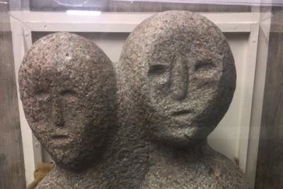
Moon-Eyed People
Here, at the Confluence of the Hiwassee and Valley Rivers, is a good place to reveal the legend of the Moon-Eyed People.
This legend has a mystic appeal, sourced from various tales passed down from long ago. Though the legend is not verified by any actual archeological evidence, the stories persist.
The legend tells of a race of rather small white skinned people with blond hair and blue eyes that occupied this area in ancient times.
These people, interesting because of their appearance were, in some stories, thought to be blind in the daylight, only able to see by the light of the moon. Thus their name: The Moon-Eyed People.
The actual origin of these people, if they ever did exist, is obscured in history.
Some stories, supported by Celtic and Welsh legend, have these people as Welsh adventurers, arriving in the area about 1170 AD. Other studies by respected researchers either conflict with these stories or fail to mention these special people altogether.
So, did they exist or not? If they did, who were they and where did they go? We may never know.
Other than these stories and legends is there any other evidence?
One possible piece of archeological evidence that may point to their existence was found right here at the Confluence of these rivers. What some believe to be a full sized effigy of these strange people was found by Felix Axley here in 1840. He was digging the footers for his new home just above this spot, when he came across this statue buried in the ground. This artifact is of unknown age or origin. Over the years, the effigy has had several owners, some as far away as Asheville, before being purchased and brought back home by our local museum. This wonderful piece of our history can be seen at our own Cherokee County Historical Museum in downtown Murphy.
Take the time to go see this historical artifact and decide for yourself if the Moon Eyed People once lived near this very spot!
Listen to the audio file describing this location here.
Native Plants
As you walk along the River Walk you will see areas that have new plants that enhance the beauty of the trail. All the trees and shrubs that have been planted along the trail are native to the local environment.
Why is it important that we use native plants along the River Walk Trail?
We often hear in the news about a plant or an animal that is near extinction and will be lost forever. The Cheetah or the California Condor are examples that often make the news. Many other animals, plants or environments have become increasingly rare. These plants and animals are threatened or endangered of extinction because of the changes in their environments and loss of habitat.
A particular type of environment is called an ecosystem. In a healthy ecosystem, all the plants, insects and animals depend on each other for food and protection. The Monarch Butterfly, which is completely dependent on milkweed for its survival, is a good example of this relationship in an ecosystem.
Native plants are an important part of maintaining a healthy ecosystem and habitat. Even the loss of a little known native plant or insect can have a broad effect on the survival of other plants or animals in these delicate environments.
When the Riverwalk Trail was constructed most of the plants in this river bottom ecosystem were invasive and non-native. These invasive plants had displaced the native plants that were an important food supply for the plant eating insects and animals that belong in this ecosystem. Nearly all leaf eating insects are chemically dependent on certain plants for their food. When their food supply is gone, these insects also disappear. When these insects disappear, the birds and animals that eat them also disappear. The healthy balance of these delicate ecosystems depends on the native plants and animals.
As construction of the trail progresses, we will continue to remove the invasive non-native plants from the area. This will encourage the native plants to reestablish and grow. Many of the native plants were always here but were suppressed by the vigorous non-native plants. Other native plants will need to be replanted as the non-native plants are removed.
We are already seeing the native plant population rebounding along the trail. Here in the wetlands area along the Fisherman’s Loop you can now find the native Swamp Rose Mallow plant that we had no idea was growing here. We wonder what insects will feed on these mallow plants and if more birds like the American Yellow Warbler or the Cliff Swallow will return to feed on those insects.
As you continue along your walk, watch for other native plants like the bald cypress, yellowwood and witch-hazel that have been reintroduced to this unique river bottom ecosystem.
Listen to the audio file describing this location here.

River Cane
River cane, seen here along the banks of the Valley River, is a type of bamboo. In fact, this type of bamboo is the only species of bamboo that is native to North America.
The plant was once very common to this area and throughout the Southeastern United States. Early European explorers to this area described vast stands of River Cane that were especially common in the river lowlands. These stands often covered hundreds of thousands of acres but these stands have declined significantly, nearly disappearing altogether due to land clearing and farming.
Before European colonization this plant was extremely important to the Cherokee and other Native American people. The plant, called I-HI (pronounced ee-hee) by the Cherokee, was used to make chairs, arrow shafts, blow guns, fishing poles, baskets and many other things needed for daily life.
Superior technology has replaced most of the products formerly made from River Cane, but the Cherokee still use it to make beautiful baskets and mats.
The plant has almost died out from the area and is hard to find, but the Cherokee Nation’s Natural Resources Department and other environmental groups are making efforts to plant new stands of cane to help revitalize its growth.
Listen to the audio file describing this location here.
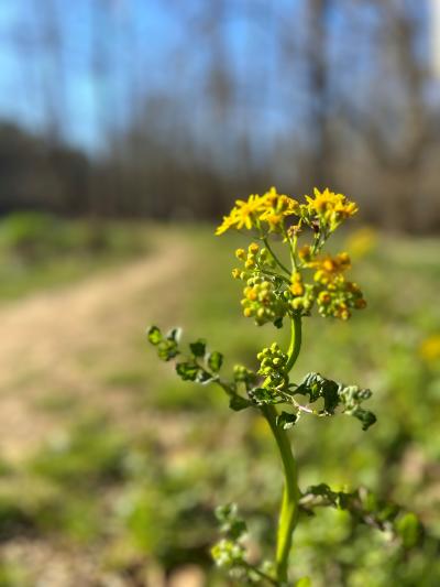
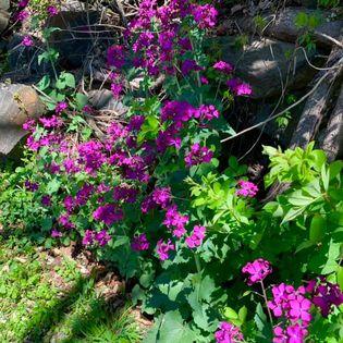
Wildflowers
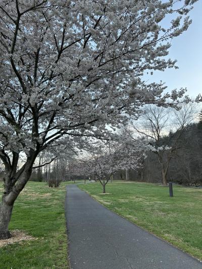
There are literally hundreds of varieties of wildflowers in the southern Appalachian Mountains. Blooming begins in March and continues into early November.
In the Spring, the wildflowers seem to show up everywhere. Some are so tiny that you can barely see them. Others seem to carpet the entire hillside.
There are too many varieties to name here, but there are a few we should mention.
One popular wildflower found in the shady parts of the trail are trillium. This is a small, low growing plant, typically with three leaves and a three pedal flower growing grom the center. Thus the name trillium. The color of the flower can range from white, yellow, lavender to burgundy.
Another one to look for is the wild violet. These small plants also grow in shady areas and the flowers can be white, blue or violet.
One somewhat rare flower to look for is the Lady Slipper. This is actually a type of orchid and is also found in heavily shaded areas.
Not all wild flowers are limited to the forest floor.
In the spring, the flowers of the dogwood tree seem to appear everywhere.
Another springtime favorite is the flower of the redbud tree. The pretty red bloom of the tree put on one of spring times most colorful shows.
So, depending on when you walk the trail, you will be delighted by the diverse wildflowers of our area.
Listen to the audio file describing this location here.
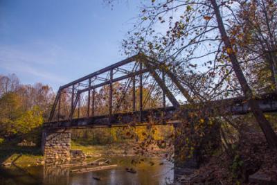
The Old Railroad Trestle
This old trestle crosses the Valley River and carries the rail that connects Murphy to Andrews, NC.
Archeological evidence indicates that this is not the original railroad bridge built when the railroad connected Murphy to points east. When the river is very low, you might be able to observe old wooden footers under the existing bridge that would have been the foundation for an earlier, wooden trestle.
These old wooden footers would have been built on shore, then floated to position before being sunk and filled with rocks to hold them in place. The wooden trestle would have been built up from this new foundation.
Just when the newer steel bridge replaced the wooden trestle is not known exactly. Presumably the new bridge was needed to carry larger and heavier trains necessary to service this growing area.
This beautiful old steel bridge stands silent now. It stands now as a monument to busier times. No train has crossed here since the last train left Murphy on July 4, 1992.
Listen to the audio file describing this location here.
The TVA
Much of the River Walk is located on land owned by the Tennessee Valley Authority, also known as the TVA. It is through a partnership between local government and the TDA that our beautiful trail is here for you to enjoy.
The TVA was created in 1933 by President Franklin D Roosevelt as part of his New Deal program to help lift the nation out of the Great Depression.
In the 40’s during World War II, the United States needed power for essential war industries—to build bombs and airplanes for example—and the government turned to TVA to help supply this electricity. At this time, the TVA engaged in one of the largest hydropower construction programs ever undertaken in the United States. Early in 1942 there were 12 hydroelectric projects and a steam plant under construction and design, and engineering and construction employment reached a peak of 28,000.
It wasn’t just power that the TVA supplied to the war effort. Raw materials like lumber, iron, phosphorus, petroleum products and food were produced and transported throughout the TVA river and reservoir system.
In the 1950’s the cheap and abundant energy combined with the year-round navigation provided on the rivers and reservoirs led to massive industrial and economic growth in the area.
Today the TVA reaffirms its mission to make life better for the people of the Tennessee Valley by providing safe, clean, reliable and affordable energy and being good stewards of the environment and the rich natural resources of the Tennessee Valley region.
Listen to the audio file describing this location here.
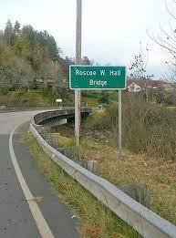
Roscoe W. Hall Bridge
The bridge you see above you connects Murphy to the Joe Brown Highway.
The Joe Brown, as it is called by the locals, follows the general route of the old Unicoi Turnpike that crosses the Unicoi Pass and continues west to Coker Creek, TN.
The road has a long history.
Originally, it was just a path that connected Cherokee towns in Tennessee to settlements in the Carolinas. During the 17th and 18th centuries, it was a major trade route for the Native Americans and the newly arriving European settlers.
In the early 1800’s, entrepreneurs converted the path to a toll road and named it the Unicoi Turnpike.
During the Cherokee Removal in 1838, the Unicoi Turnpike was the first leg of the journey for the Cherokee people who were being deported from North Carolina. Thus, this road became the beginning of the Trail of Tears.
By the time of the Civil War, the old road was largely abandoned in favor of other transportation routes, but a toll gate remained in operation on Unicoi Gap until the turn of the 20th Century.
The Joe Brown and the Unicoi Turnpike remains as a popular tourist route through our mountains, especially during the Fall foliage season.
In 2015, this bridge was dedicated to the memory of Roscoe W Hall, a popular resident and community leader.
Listen to the audio file describing this location here.
Wetlands
Much of the low lying land along these rivers is classified as wetlands.
Wetlands are areas that are saturated of covered with water for at least part of the year.
The areas along the River Walk that are classified as wetlands are along the Cypress and Fisherman’s Loop trails.
Wetlands are an important part of our natural environment and their protection is an essential part of maintaining a healthy ecosystem in our area.
The role of wetlands as wildlife habitat has long been recognized. In North Carolina, more than 70% of the species listed as endangered or threatened depend on wetlands for their survival. Many other common species of waterfowl, fish, birds, mammals and amphibians live in wetlands during critical stages of their lives.
These river bottom wetlands provide abundant food, nesting sites, resting areas and escape cover for many wildlife species. Many fish species use the flooded areas for spawning and feeding locations.
Our wetlands provide opportunity for birdwatching, canoeing, kayaking, hiking and photography. Without these wetlands, this area would have much less wildlife diversity and would be a much less interesting place to visit.
Listen to the audio file describing this location here.
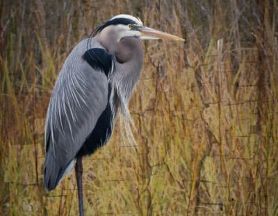
Wildlife
Murphy River Walk, as wild and scenic as most of our trails are, is still considered to be in an urban area. Even so, this area is an important host to a wide variety of wildlife.
Most prevalent are the birds. Ducks, geese, herons and egrets are common. Birds of prey like the Osprey, Bald Eagle and several varieties of hawks and owls are frequently spotted.
As you walk the trail, songbirds like the blue bird, finches, tufted titmouse and many others provide a pleasant song throughout most of the year.
Robins, cardinals, blue jay, redwing blackbirds and several varieties of swallows are just a few of the other birds you might see.
The list of wildlife is not limited to birds.
As you walk along the Fisherman’s Loop during time of low water, you might notice several large holes in the opposite bank of the Valley River. These are openings to the underground homes of the bank beaver. Normally these openings are under water, but when the river is low, they are easily seen. Watch for the occasional beaver swimming in this area. They are shy so they are not seen often.
Other animals that you might see are raccoons, opossum, woodchucks, rabbits or squirrels.
Because this is an urban area, sightings of larger animals are uncommon but do happen. Sightings of deer occur regularly. Sightings of other large animals like the black bear, bobcat, or mountain lion are unlikely, but have occurred on rare occasion.
So keep your eyes and ears open. You never know what you might see.
Listen to the audio file describing this location here.